Leica MC1 - 3D Excavator System

ExcavatorsHeavy ConstructionLeica GeosystemsMachine Control Leica MC1 - 3D Excavator System
Call for price
01 627 09753D Excavator Machine Control Solution
3D machine control from LeicaMC1 is a highly advanced 3D excavator system for machine control solutions. Complex excavating jobs can be handled easily and with high accuracy, saving you a lot of time and cost by eliminating grade checking and reducing rework.
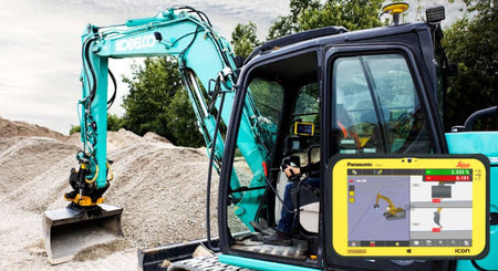
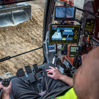
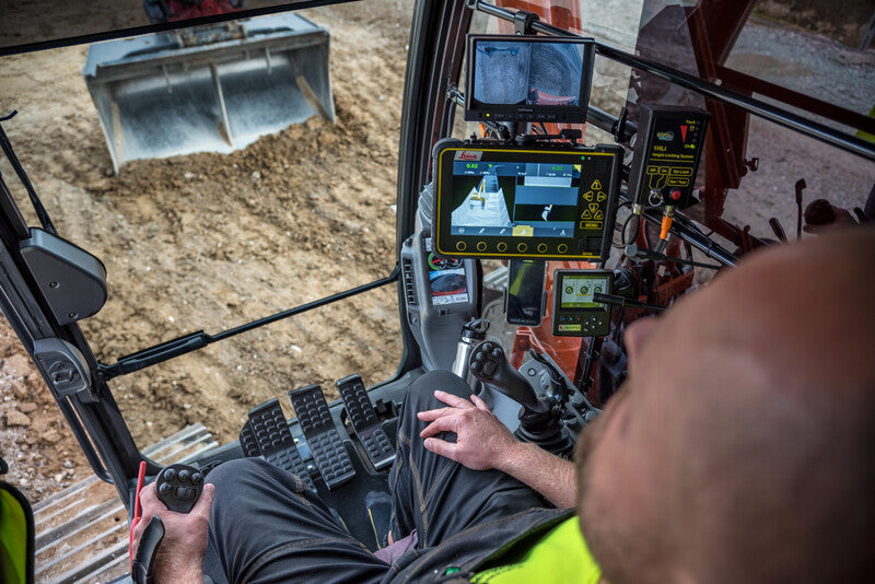
The MC1 machine control solution guides the operator using reference models and GNSS in 3D. Design information and real-time cut/fill indications are displayed in the cab on your control panel, allowing you to rapidly excavate to the reference design. The solution ensures more uptime and operator satisfaction while increasing safety and productivity. Work with a wide range of industry-standard data formats including LandXML, DXF, GEO, KOF, L3D, LMD, LIN, MBS, and TRM formats, which offers the customer a variety of applications and workflows. The operator can use the function Create Model to make simple and complex models on the fly without leaving the cab and without the assistance of a surveying engineer.
The advanced 3D software allows you to create simple terrain models directly in the control panel - a new feature providing great flexibility in the field. With the unique PowerSnap concept, Leica MC1 simplifies system installation and enables the rapid interchange of control panels between machines in your fleet.
The system supports Leica iCON telematics which enables you easy data transfer from office to machines, remote support, and fleet management via the iCON telematics website.
Advanced 3D guidance
Leica MC1 uses 3D design (CAD) models and state-of-the-art GNSS technology to guide the operator. Design information and real-time cut/fill indications are displayed in the cab on your control box, allowing you rapid excavation to the reference design. The system eliminates the need for grade checking, increasing both safety and productivity. No need for surveyors to enter the earthworks area.
Integrated tilt rotator support
Leica MC1 provides integrated tilt rotator support, giving the operator clear guidance information about the actual tilt and rotation position relative to his project. MC1 excavate with tilt rotator support increases your productivity and lets you maximize the use and benefits of your machine control solution.
- Work directly from CAD models with Leica MC1
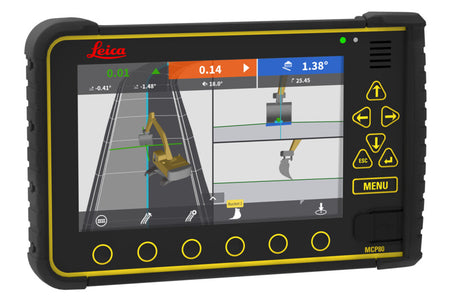
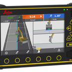
- Switch between 2D and 3D view with the touch of a button
- Full guidance with rich 3D graphics see the job how you need to, see section, profile and 2D/3D view
- Create simple terrain models directly on the screen
- Compatible with most makes and models of excavators on the market even dual boom excavators supported
- Improve site safety - MC1 removes the need for grade checkers to enter the earthworks area
- Eliminate over-excavation and costly material overruns
- Work without boundaries increases machine productivity by reducing your dependency on-site survey teams
- Creates a greener site reduced rework and increased productivity all add up to substantial fuel savings, as well as reduced machine hours, as the job gets done quicker!
- Construct complex geometries, profiles, and grades in a fraction of the normal time. Handle "blind" and underwater excavation with ease
- Operator-friendly, easy-to-understand user interface reduces training time and costs
- Upgrade easily from 2D to 3D in the same control panel
- Full payback on your investment can be achieved in one project
- Full support of iCON telematics services
- Precise sculpting of edges, slopes, and contours by the support of tilt rotator attachments
PowerSnap technology
Do you want to use your control panel on several machines in your fleet with an easy, quick install? PowerSnap allows the simple and fast exchange of the panel between different machines.
The patented Snap-on & Snap-off technology from Leica Geosystems allows machine sensors and control panels to be interchanged for rapid reconfiguration of machine control hardware. Swapping control panels and sensor technology has never been easier and faster - alter machine capabilities as your project needs change.
- The system is up and running in no time
- Rapid interchange of control panels between machines, giving you extra flexibility on site
- One Cradle for all iCON excavate and iCON grade panels
- Easy removal of core components for overnight security
- Contact and cable-free connection to control/display panels
- Safety shutdown feature protects the system and data
- Cradle stores machine-specific settings such as hydraulic tuning
- Unique patented Snap on/Snap off capability
System applications
The days of being constrained and relying on batter rails, boards and string lines is coming to an end, with the revolutionary Leica MC1 system. Typically a site survey will be conducted; turning physical data into terrain models. As the construction process continues, this data is interpreted into rails, boards and other markers. This takes time not to mention expense!
Using Leica MC1 the operator works directly from the original 3D data produced by site engineers. Operators can then reach target depth and grades with ease. Using the Bluetooth and wireless capabilities of the Leica MCP80 display screen the data can be sent straight back to the site office speeding up excavation and preventing over/under dig. This will positively impact project costs and make you more profitable!
System Uses
Trenching
Use the system to provide sub-centimeter depth guidance for any application. Simply enter the desired depth and slope into the in-cab display, or work directly from the original 3D terrain models. All this without the need for grade checkers to enter the excavation area.
Blind & Submerged Cuts
Use the system to 'see' underwater designed specifically for dredging, clearing and operating in water. Just follow the position of the bucket by means of seven bucket position indicators on the full colour, 3D rendered display.
Formation Layering
When filling material in pipe trenches or formations, just enter the desired material depth and slope required. The system can store multiple depths and slopes for several layers.
Grading
Grading uneven surfaces can be done with speed and ease. Just enter the desired depth and slope into the in-cab display or work directly from GNSS coordinates. Grading has never been so simple.
Height Alarm
Safety First - When digging in surroundings where there are objects above the excavator that are potentially dangerous (e.g. power cables), you can set an Alarm Height that warns the operator of boom, stick, and bucket heights.
You May Also Like